
There is a small, vacant piece of land behind the church on the corner of Shamrock and Selkirk that many Selkirk residents use to drive over to Hurley’s. It isn’t an official road and is currently only usable for robust vehicles, and I was wondering if the Government has ever looked into purchasing that property to use as a proper road? It would give all of the Selkirk residents heading into town in the morning an option to avoid turning left on Shamrock and joining/clogging the Prospect roundabout.
Auntie’s answer: Your question actually required piecing together various bits of information to provide as complete a picture as possible, and all thanks to a very patient official at the National Roads Authority (NRA). To help with the explanation, I have been supplied a visual aid, a map of the aforementioned section:
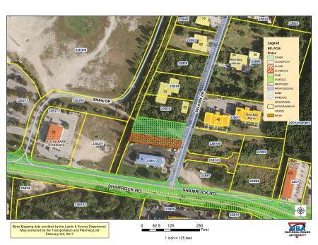 We can start with the plot of land behind the church. The parcel right behind that structure (which is shaded green in the map) is gazetted and part of the public road system, the NRA person explained. However, the strip of land between that parcel and Bimini Drive, which is the road that leads to Grand Harbour to the left and to a residential area to the right, is private. At this time, there are no plans to pave the part of the road that is public.
In addition, as I mentioned, Bimini Drive is a private road, so it doesn’t seem to me that the government would be willing to buy the remaining parcel and create public access to a private road to improve commute time.
I realise I may sound harsh and slightly cynical here. I am no fan of sitting in traffic, either, but I think building that road would open up a fairly good-sized tin of worms that no one would want to deal with.

Whoever runs in Red Bay better have this on his political agenda if he wants my vote.
You would still have to turn left out of Selkirk, because the only other option would be to drive through Hurley’s parking lot to get on to the runabout.
I don’t think Hurley’s would appreciate a constant stream of traffic, cutting across their parking lot week day mornings especially… pass the pharmacy onto the roundabout.
A Runabout is a small car, motorboat or light aircraft, especially one used for short trips….If it was the light aircraft you were trying to ‘get on to’ then you shouldn’t have a problem with traffic ?
It was just a joke Mr or Mrs Troll..a little bit of humour…something you obviously sadly lack….lighten up!
I agree 2.56 ….the Dislikes and Trolls have nothing better to do with their lives…The joke’s on them because when they react like that to a light -hearted post like yours…they look like the fools they are…with nothing better to do than hate…they probably didn’t even understand what your post was referring to (if they could actually read & write- as opposed just marking their ‘x’ )…..sad lives, sad little people!